Microclimate Mapping: Understanding SF's Weather Zones
What is Microclimate Mapping and Why Does it Matter?
Microclimate mapping refers to the study of small-scale climate variations within a larger area. In a city like San Francisco, this is particularly important due to its diverse geography, which includes hills, water bodies, and urban development. Understanding these microclimates can help residents and visitors alike better prepare for the city's unpredictable weather patterns.
The best way to predict the future is to create it.
For instance, you might experience a sunny day in the Mission District but find fog in the Sunset. This variability can significantly affect everything from gardening to planning outdoor activities. By mapping these microclimates, we can gain insights into local weather phenomena, making our time in SF more enjoyable and productive.
Moreover, microclimate mapping can aid urban planning and environmental conservation efforts. By recognizing how different areas respond to climate change, planners can implement strategies to mitigate adverse effects, ensuring a more resilient city for future generations.
San Francisco's Unique Geography and Its Impact on Weather
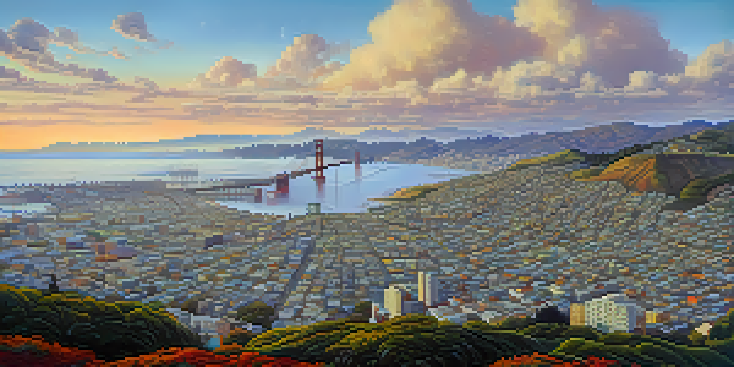
San Francisco's distinct geography plays a crucial role in creating its varied microclimates. The city's location on the Pacific coast, combined with its hills and valleys, leads to significant weather differences just a few blocks apart. This is why one neighborhood might be basking in sunlight while another is shrouded in fog.

The Golden Gate Bridge acts as a barrier, funneling cool ocean air into the bay and creating foggy conditions, particularly in the western neighborhoods. Conversely, areas further inland can be much warmer and drier, showcasing the stark contrast in weather. Understanding these geographical influences helps residents adapt their activities to the local climate.
Understanding Microclimates
Microclimate mapping reveals small-scale weather variations in San Francisco, helping residents better prepare for diverse climate conditions.
Additionally, the urban heat island effect can intensify temperature variations. Dense urban areas absorb and retain heat, leading to higher temperatures compared to surrounding parks and waterfronts. This phenomenon is essential for anyone looking to understand how SF’s neighborhoods experience different weather conditions.
Popular Microclimate Zones in San Francisco
San Francisco boasts several notable microclimate zones, each with its own unique weather characteristics. For instance, the Mission District is known for its sunny and warm conditions, making it a popular spot for outdoor dining and festivals. In contrast, the Richmond and Sunset districts are notorious for their cooler, foggy weather, particularly in the summer months.
In the middle of difficulty lies opportunity.
Another interesting zone is the Financial District, where high-rise buildings can create wind tunnels, affecting temperatures and comfort levels. Even the Presidio, with its lush greenery, has microclimates that can be both cooler and more humid compared to the surrounding urban areas. These variations shape the lifestyle and activities of residents and visitors alike.
Being aware of these microclimate zones can help you dress appropriately or plan your outings better. Whether you're planning a picnic in Dolores Park or a hike in Golden Gate Park, knowing the expected weather can make all the difference in your experience.
How Microclimate Mapping Works: Tools and Techniques
Microclimate mapping employs various tools and techniques to gather data about weather patterns. Meteorologists use advanced weather stations, satellite imagery, and even smartphone apps to track temperature, humidity, and precipitation levels in real-time. This technology allows for a detailed analysis of how microclimates operate within the city.
One popular method involves deploying small weather sensors across different neighborhoods to collect localized data. This information is then compiled into visual maps that illustrate temperature variations and other climate factors. These maps can be invaluable for both residents and city planners to understand and respond to local weather conditions.
Impact on Urban Planning
Microclimate data informs urban planning decisions, allowing for the creation of more sustainable and functional city spaces.
Additionally, citizen science initiatives have emerged, enabling residents to contribute their own weather observations. This grassroots approach not only fosters community engagement but also enriches the data available for accurate microclimate mapping.
The Role of Microclimates in Urban Planning
Microclimate mapping plays a vital role in urban planning, helping city officials make informed decisions about development and infrastructure. By understanding how different areas respond to climate variations, planners can create spaces that enhance both functionality and sustainability. This is especially important in a city like San Francisco, where geography significantly influences everyday life.
For instance, planners might prioritize the development of green spaces in areas that experience higher temperatures, providing relief from heat and improving air quality. Similarly, recognizing fog-prone areas can inform decisions on where to place solar panels, ensuring maximum efficiency in energy production.
Furthermore, microclimate data can guide disaster preparedness efforts, such as flood risk assessments and wildfire management. By taking these localized weather conditions into account, San Francisco can better protect its community and environment.
Personalizing Your Experience Based on Microclimates
Understanding microclimates can significantly enhance your experience in San Francisco. By knowing which neighborhoods are typically warmer or cooler, you can tailor your activities accordingly. For example, if you're planning a beach day at Ocean Beach, it’s wise to check the weather in the Sunset for potential fog before heading out.
Additionally, gardeners can benefit from microclimate knowledge. Certain plants thrive in specific conditions, so understanding your local microclimate can lead to a more successful gardening experience. Whether you're growing tomatoes in the Mission or succulents in a sunny spot in Noe Valley, knowing your zone is key.
Future of Mapping Technology
Advancements in technology and community engagement in citizen science will enhance the accuracy and relevance of microclimate mapping.
Moreover, this understanding can help you dress appropriately for the day. Layering is essential in SF, as you might start your day in the chilly fog and end it basking in sunlight. By being aware of the microclimates, you’re better prepared for whatever the city throws your way.
Future of Microclimate Mapping in San Francisco
The future of microclimate mapping in San Francisco looks promising, with advancements in technology and data collection methods. As more people engage with citizen science projects, the data pool for microclimate analysis will expand, leading to even more accurate maps. This collaborative effort not only enriches our understanding but also fosters a sense of community involvement in local environmental issues.
Furthermore, as climate change continues to influence weather patterns, microclimate mapping will become increasingly crucial in urban planning and environmental conservation. Understanding how these changes impact specific neighborhoods will enable city planners to develop adaptive strategies that promote sustainability and resilience.
Ultimately, the ongoing evolution of microclimate mapping will continue to enhance our ability to navigate the unique weather of San Francisco. By embracing this knowledge, we can all make more informed choices in our daily lives, contributing to a more adaptable and connected city.